
ASTROPHYSICS
THE METEORITE EXPEDITION TO P0DK4MENNAYA TUNGUSKA IN 1939
By L. A. KULIK
(Communicated by W.I. Vernadsky, Member of the Academy, 10. IV. 1940)
The expedition sent by the Academy of Sciences to locate the fall of the Tungus meteorite in 1908, set out from Moscow on July 12, last year. It proceeded by train to Krasnoyarsk; from there by airplane to Kezhmy, which lies on the Angara river, and then on horseback from Vanovara to Podkamennaya Tunguska and to the field at the center of the meteorite fall.
Having arrived at its destination on August 6, the expedition formed one geodetic and one geological party. The geodetic party included engineer N. S. Aprelev and two workers; on September 3 two more workers were taken, and they worked till the end of the season. The geological party included assistant engineer E. L. Kulik and one worker.
Four more workers were expected from Vanovara, but for some reason they were delayed, and the expedition decided in the meantime to engage the geodetic party in the work of setting out the geological sounding lines on an area of one kilometer on the Great Southern marsh. The work was begun on August 8 and completed on August 12. On August 13, both parties left for the field where their main work was to be done.
To prepare for the aerial survey of the locality of the meteorite fall, the geographical coordinates of the storm center of that fall—Farrington Hill—were, with the aid of the Society for Air and Chemical Defense, ascertained by II class astro-radio means as far back as 1929.
In 1937, with the aid of the Central Administration of the Northern Sea Route, the geodetic base-line was measured at the center where the trees were presumably felled by the meteorite, a triangulation network, class V, was set up for small scale photosurveying, and paths with various signals were laid out for the tacheometric party.
In 1938, likewise with the aid of the Central Administration of the Northern Sea Route, all this field on which preliminary geodetic work had been done previously, was surveyed from aircraft and put on a scale of 1: 4700. An automatic AFA-13 camera produced by the Geodesia Plant, with a VOMP lens (focal distance 300 mm) was used. Altogether 1500 negatives, size 18 x 18, were obtained. But, although the negatives were faultless, the photographs showed physical and photogrammetric gaps. This is to be explained by the fact that the geodetic work done in 1937 was meant to provide a basis only for a small scale aerial survey, so as to obtain a relief with a normal phototriangulation. For some reasons, however, no small scale aerial survey was made in 1938. Owing to the insufficiently salient contours of the slightly undulating taiga and other unfavourable conditions, the photographs proved unsatisfactory, and supplementary geodetic work had become necessary so as to make the network of base lines more close. This supplementary work was carried out by engineer Aprelev's geodetic party in the months of August, September and October of last year. Notwithstanding the limited time at the disposal of the expedition (the season was too far advanced for field work in this part of the country), the set task was accomplished, greatly facilitating the work of mapping this locality at the Academy.
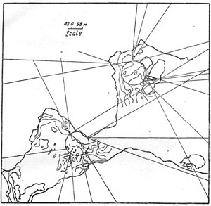
Fig. 1. Scheme of the western part of the Great Southern Marsh with two centers of direction of tree-fall and isobaths, plotted according to the work done in 1939. Scale—1 cm = 48 m. The contours of the Great Southern Marsh, of the «islands» with the areas of frozen hilly turf-pits preserved on them, are shown with a thick line. The isobaths of the marsh bottom as taken in 1939 are denoted with a thin line. Straight lines indicate the direction of fallen trees; the centers are denoted with circles.
The tacheometric party traversed 42 km and filled the gaps left in the aerial survey of 1938. Simultaneously with this geodetic survey, the writer of these lines who was directing the entire work, was also engaged in determining the configuration of the bed of the sections of the Great Southern marsh that are in the centers of the direction in which the trees fell at the time of the meteorite fall. Having arrived at the place rather late with only a brief spell of the warm season, remaining at our disposal, we could only tackle two sections of the marsh—the «western» and «central», near «the islands» (Fig. 1). The latter, owing to the abundance of water, was covered with a network of sounding points only 40 m apart from each other. The soundings were taken by means of the Hiller peat bore, the average depth being from 5 to 6 m.
The western section which, having less moisture, is passable, has also been covered by a network of sounding points (Fig. 2). The soundings at the southern division of this section showed greater depths, up to 8 m, and a more varied configuration than in its northern division. This necessitated our taking sounding at closer intervals—first at intervals of 20 m; then at intervals of 10 and even 5 m. As a result, we have established the existence of depressions of different depths (from 2.5 to 3 m at distances of from 5 to 10 m), the sediments at the bed differing from those further north (Fig. 3). Instead of the usual structure: peat, slime, mineral slime (in successive order of layers from top to bottom), here they are chaotically mixed up. Sometimes the samples showed an alternation of layers of various structural elements.
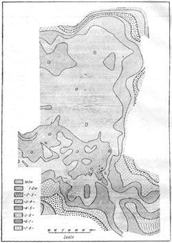
Fig. 2. Great Southern Marsh. Central part of the western section. Photo taken of a colour-pencilled map on an orthochromatic plate; an orange filter No. 4 was used. Colours of the left part of the spectrum stand for smaller depths, those of the right part for great ones. By figures are denoted the points of sounding pickets according to the 40 and 20 meter scale. The greatest depths and the anomalies of bottom sediments are located somewhat westward from the entrance of the strait.
More often they showed a mixture of peat, slime and mineral substratum (green slime or green sand) (Fig. 4). Here it was impossible to precast the lie of the strata even five meters ahead. The general configuration of this locality as well as of the bed and surface of the marsh leads one to believe, that very likely it was here that the underground waters burst out of the frozen soil after the fall of the fragments of the meteorite. It is this burst of water that may account for the washout in the slimes at the bottom of the marsh in the direction of the Ghurguim river (which collects the outflowing waters from the marsh), as well as the gradient of the marsh itself which governs the direction of the flow of the water.
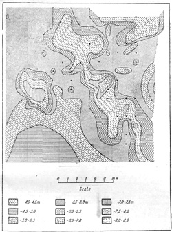
Fig. 3. Great Southern Marsh. Central part of the western section. Photo taken of a colour-pencilled map, on an orthochromatic plate, with an orange filter No. 4. The colours of the left part of the spectrum show smaller depths, those of the right part— greater ones. Spots where anomalies of bottom sediments were observed are denoted with points.
It should be noted that this place is also in the center at which all the crowns of the fallen trees are pointing. On the map this place corresponds to the southern segment of the circle denoting the center (Fig. 1). Taking into consideration that the direction indicated by the crowns of the fallen trees has been drawn tentatively in accordance with a field aerial photoscheme, the coincidence is pretty close. The same picture is to be observed on the section near «the islands». This leads us to believe that, when the exact photomap is finally produced, both these centers will have been shifted to the south and the coincidence will be complete.
Nearly one thousand sounding pickets have been ranged and 925 samples taken from the bed by the geological party, between August 13 and September 20. Snowfall and the freezing of the marsh put an end to the labours of the geological party. It is, however, to be hoped that this work will be resumed at a favourable opportunity and will cover the entire area of the marsh or at least will be carried to the meridian of the «islands» near the eastern center of the fallen trees.
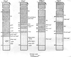
Fig. 4. Vertical sections with bottom anomalies. Great Southern Marsh. Western center of the tree-fall. Vertical sections of some sounding points with anomalous distribution of bottom sediments.
The Meteorite Committee of the Academy, with the cooperation of the Terrestrial Magnetism Institute, intends to do some surveying in these localities with the magnet this year.
It is desirable that this work should be extended to all the places where the meteorite is supposed to have fallen, and the people engaged in this work should not lose sight of the Earth's magnetic field in these localities as well as the diurnal course and local influences.
Meteorite Committee. Academy of Sciences of the USSR.
Received 19. IV. 1940.